Click image to zoom
Aerial View Of The Nevado De Toluca
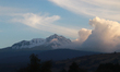
An aerial view taken with a drone shows the Nevado de Toluca volcano, also called Xinantecatl, which reaches a height of 4,680 meters above sea level, located in the Toluca Valley, 22 km southwest of the state capital, Toluca, in Toluca de Lerdo, Mexico, on January 25, 2025. (Photo by Carlos Santiago/ Eyepix Group) (Photo by Eyepix/NurPhoto)
Photo Details
| Photo ID | #11983656 |
|---|---|
| Date Taken | |
| Location | N/A |
| Photographer | Eyepix/NurPhoto |
| Category | Human Interest |
| Copyright | © 2026 NurPhoto - Eyepix/NurPhoto |
Related Keywords
nevado de Toluca
volcano
state of mexico
toluca
frozen
cold
aerial view
nature
atmosphere
mountain
Xinantécatl
Toluca Valley
4
680 meters
southwest of the state capital
toluca capital
Toluca de Lerdo
general view
snowy volcano
snow
Aerial view
drone
Nevado de Toluca
Xinantécatl
volcano
height
4
680 meters
sea level
Toluca Valley
southwest
state capital
Toluca
January 25
2025
Toluca de Lerdo
Mexico
Carlos Santiago
Eyepix Group
Eyepix
NurPhoto
photography
geographical location
natural landmark
volcanic peak
elevation
Mexican volcano
landscape
aerial photography
geographic feature
Toluca region
volcanic activity
natural wonder
mountain
topography.
2026 NurPhoto. All rights reserved.
This image is the property of NurPhoto and is protected under international copyright laws.
Similar Photos
View All