Click image to zoom
Jiri- The Trekking Gateway To The Everest Region Of Nepal
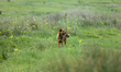
Students play in an open ground of a school in Jiri, Nepal, on May 20, 2025. Jiri is situated in the northeastern part of Nepal. Jiri lies at an elevation from 1,649 meters to 5,341 meters above sea level and occupies 211.25 square kilometers of land area. It is known as the gateway to the Everest Region and serves as a popular starting point for treks to the Everest Base Camp. It usually takes about 20 days for trekkers to reach the Everest region. (Photo by Subaas Shrestha/NurPhoto)
Photo Details
| Photo ID | #12389417 |
|---|---|
| Date Taken | |
| Location | N/A |
| Photographer | Subaas Shrestha/NurPhoto |
| Category | Human Interest |
| Copyright | © 2026 NurPhoto - Subaas Shrestha/NurPhoto |
Related Keywords
students
open ground
school
Jiri
Dolakha District
Nepal
20 May 2025
north eastern Nepal
elevation
sea level
land area
1649 m
5341 m
211.25 km
gateway
Everest Region
starting point
treks
Everest Base Camp
trekkers
20 days
Subaas Shrestha
NurPhoto
photo
play
situated
popular
famously known
reach
Jiri elevation
Jiri land area
Jiri location
Jiri trek
Everest trek.
2026 NurPhoto. All rights reserved.
This image is the property of NurPhoto and is protected under international copyright laws.
Similar Photos
View All