Click image to zoom
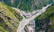
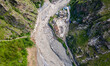
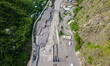
Aerial View Of Rasuwagadhi Flood Devastation In Nepal
The aerial view shows the Rasuwagadhi flood destroying a Friendship bridge, road, a hydropower substation, and sweeping away vehicles in Rasuwa, Nepal, on July 12, 2025. Local roads between Syabrubesi and Rasuwagadhi, including the Pasang Lhamu Highway, are washed out in multiple locations. (Photo by Ambir Tolang/NurPhoto)
Photo Details
| Photo ID | #12548336 |
|---|---|
| Date Taken | |
| Location | N/A |
| Photographer | Ambir Tolang/NurPhoto |
| Category | Disaster and Accident |
| Copyright | © 2026 NurPhoto - Ambir Tolang/NurPhoto |
Related Keywords
aerial
aerial view
ambir tolang
ap tolang
asia
bhotekosi
bridge
climate
climate change
climate chaning
disaster
drone
drone shot
drone view
emergency
flood
global issue
global warming
hill
landslide
nepal
outdoor
rasuwa
rasuwa boarder
rasuwa flood
risk
river
road
tourism
travel
trishuli river
weather
2026 NurPhoto. All rights reserved.
This image is the property of NurPhoto and is protected under international copyright laws.
Similar Photos
View All