Click image to zoom
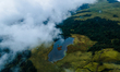
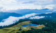
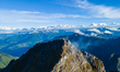
The Aerial View Shows Silichong Peak
The aerial view shows Silichong Peak in Bhojpur, Nepal, on October 1, 2025. Silichong, at an altitude of 4,153 meters, is the highest point in the Bhojpur district of Nepal. The peak lies at the intersection of four districts: Bhojpur, Khotang, Solukhumbu, and Sankhuwasabha. (Photo by Ambir Tolang/NurPhoto)
Photo Details
| Photo ID | #12855831 |
|---|---|
| Date Taken | |
| Location | N/A |
| Photographer | Ambir Tolang/NurPhoto |
| Category | Economy, Business and Finance |
| Copyright | © 2026 NurPhoto - Ambir Tolang/NurPhoto |
Related Keywords
AP Tolang
aerial
aerial photography
ambir tolang
animal
asia
asian
bhojpur
cloud
cloudscape
drone
drone shot
drone view
foggy
hiking
hill
holiday
koshi
lake
monsoon
mountain
mountain hill
mundhum
nature
nepal
nepalnews
nepalupdate
outdoor
peace
peak
pond
salpa
secenery
silichong
silichung
tourism
travel
trekking
vacation
water
weekend
weekend activities
2026 NurPhoto. All rights reserved.
This image is the property of NurPhoto and is protected under international copyright laws.
Similar Photos
View All