Click image to zoom
Plateau Of India - Ajodhya Hills
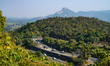
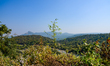
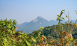
Ajodhya Hills in Purulia, India, is a small, rocky, table-topped plateau and a residual hill range, acting as the easternmost extension of the Chota Nagpur Plateau and Dalma Hills. Situated at an average altitude of 600-700 meters, it features undulating terrain, deciduous forests, and deep river valleys, and is part of the Eastern Ghats range. This is one of the untouched regions of West Bengal where there is little development, but the government improves the roads here to facilitate travel to various parts of the state. Sirkabad's turning point is located at the village of Sirkabad on the Purulia to Ajoydha road. From above, it resembles an 'S', giving it its name. The viewpoint offers a view for tourists of Ajoydha Hills and the S-shaped road with vehicles at Sirkabad in Purulia, India, on January 11, 2026. (Photo by Soumyabrata Roy/NurPhoto)
Photo Details
| Photo ID | #13228034 |
|---|---|
| Date Taken | |
| Location | N/A |
| Photographer | Soumyabrata Roy/NurPhoto |
| Category | Human Interest |
| Copyright | © 2026 NurPhoto - Soumyabrata Roy/NurPhoto |
Related Keywords
Soumyabrata Roy
NurPhoto
photography
photojournalism
image
photographer
visual media
picture
news agency
reportage
editorial photography
photo credit
professional photographer
media outlet
photo service
visual storytelling
press photo
digital image
photo distribution
image licensing
photo archive
news photography
photo coverage
photo documentation
photojournalist
visual documentation
press agency
photo collection
media photography
photo gallery
photojournalism agency.
Rights-Managed (RM) · Single Editorial Use
License This Image
Configure usage rights. Price adjusts in real time.
One license covers one publication within the parameters you select. Each additional publication (e.g. separate articles, posts, issues) requires its own license. License terms ›
Need custom or commercial rights?
Contact Sales
· [email protected]
2026 NurPhoto. All rights reserved.
This image is the property of NurPhoto and is protected under international copyright laws.
Similar Photos
View All