Click image to zoom
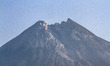
Crater Of Mount Merapi
Mount Merapi was seen from Kalitengah Lor village, in Yogyakarta, Indonesia on August 11, 2019. Based on the Research and Technological Development for Geological Disaster Agency (BPPTKG) data, Mount Merapi in level 2 status alert since May 2018, but the residents keep doing daily activities around 4 kilometers from the summit of Mount Merapi. (Photo by Rizqullah Hamiid/NurPhoto)
Photo Details
| Photo ID | #4753090 |
|---|---|
| Date Taken | |
| Location | N/A |
| Photographer | Rizqullah Hamiid/NurPhoto |
| Category | Human Interest |
| Copyright | © 2026 NurPhoto - Rizqullah Hamiid/NurPhoto |
Related Keywords
NurPhoto
General News
Mount Merapi
Indonesia
Crater
Mountainous landforms
Mountain
Mountain range
Ridge
Massif
mountain
outdoor
snow
sky
nature
summit of Mount Merapi
Geological Disaster Agency
data
BPPTKG
Technological Development
Kalitengah Lor village
kilometers
level
Yogyakarta
Research
status alert
daily activities
Rizqullah Hamiid
2026 NurPhoto. All rights reserved.
This image is the property of NurPhoto and is protected under international copyright laws.
Similar Photos
View All