Click image to zoom
Amazon Forest Fire
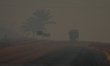
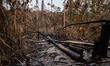
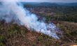
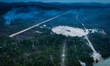
Overview of burnings in the vicinity of the BR-163 highway in the state of Pará, northern Brazil, in the Amazon region, on August 29, 2019, August 29th. Brazil's second largest corridor for soybean production - the second largest in the world - the BR-163 concentrates many of the fires that every year take over the skies of the country and even of the South American continent. Despite the creation of protected areas along more than 1,000 km of the highway, areas such as Jamanxim National Forest and Serra do Cachimbo Biological Reserve are among the most devastated (Photo by Gustavo Basso/NurPhoto)
Photo Details
| Photo ID | #4856782 |
|---|---|
| Date Taken | |
| Location | N/A |
| Photographer | Gustavo Basso/NurPhoto |
| Category | Environmental Issue |
| Copyright | © 2026 NurPhoto - Gustavo Basso/NurPhoto |
Related Keywords
NurPhoto
General News
Social Issue
Forest Fire
Amazon Forest Fire
Environment
Environment Issue
Forest
Amazonia
Brazil Forest Fire
FIre In Amazonia
Aerial photography
Sky
track
ground
outdoor
tree
highway
northern Brazil
largest corridor
creation of protected areas
Jamanxim National Forest
Serra
Cachimbo Biological Reserve
soybean production
state of Pará
Gustavo Basso
Brazil's
vicinity
country
concentrates
Overview of burnings
Amazon region
world
South American continent
year
skies
fires
PARA
Rights-Managed (RM) · Single Editorial Use
License This Image
Configure usage rights. Price adjusts in real time.
One license covers one publication within the parameters you select. Each additional publication (e.g. separate articles, posts, issues) requires its own license. License terms ›
Need custom or commercial rights?
Contact Sales
· [email protected]
2026 NurPhoto. All rights reserved.
This image is the property of NurPhoto and is protected under international copyright laws.
Similar Photos
View All